Interactive case file · Andalucia, Spain
Measuring Ground Motion from Space
Area-based measurements, optical context and explicit limits—demonstrated on two public sites using the same 91 Sentinel-1 passes.
01 · Controlled comparison
Same satellite dates. Different ground.
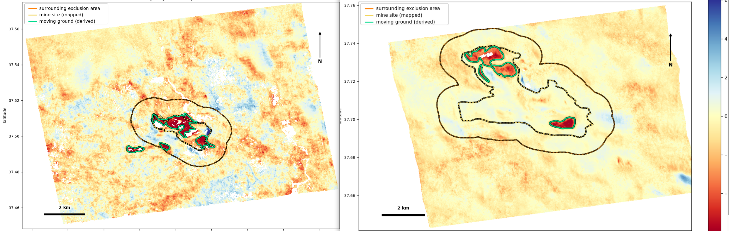
Both public examples use the same orbit and passes from 3 January 2018 to 27 June 2019. Neither operator is a client. The measurements are retrospective and do not describe current conditions.
Riotinto · Control case
Expected signatures of mine working
- Derived areas
- 3
- Outside area above threshold
- 0.0 ha
- Split-run differences
- 1.4 / -0.8 / -1.6 mm/yr
The three areas sit on the working pit floor and tailings surfaces. Rates are along the satellite line of sight.
Cobre Las Cruces · Method case
A documented historical event
- Derived areas
- 4
- Best split difference
- 1.0 mm/yr
- Still-ground spread
- 10.51 mm/yr
Two areas beyond the supplied polygon sit on the mine's tailings and water-management facility. They are a boundary caveat, not detections on unrelated ground.
02 · Figure library
Follow the result back to its context
Switch between velocity maps, optical context, area-median plots and site summaries. Click a figure to enlarge it. Optical brightness differences are not measured change.
03 · Verification
What held, and what did not
These checks are presented beside the findings so the cleaner Riotinto result does not conceal the wider spread at Las Cruces.
Riotinto
Control result
- Outside ground checked
- 9,766.7 ha
- Outside area above threshold
- 0.0 ha
- Still-ground robust spread
- 5.88 mm/yr
- Still-point median
- +0.9 mm/yr
All three reported areas recur in the split runs and are attributed to ordinary mine working.
Cobre Las Cruces
Harder method case
- Derived areas
- 4
- Still-ground robust spread
- 10.51 mm/yr
- Still-point median
- −0.2 mm/yr
- Closest split-run difference
- 1.0 mm/yr
Movement is measurable, but this series does not reproduce the published pre-event acceleration. Two areas beyond the supplied boundary belong to the mine's tailings and water-management facility.
Interpretation boundary
This retrospective case file uses public satellite data and supplied analysis boundaries. It is not a current site assessment, safety determination, engineering advice or forecast. The Las Cruces series does not resolve the acceleration described in the published study. Data and interpretations may contain errors or omissions; decisions affecting safety, property, operations or compliance require independent, site-specific verification by qualified professionals. Neither site operator was involved or is a client.
Attribution and method boundary
Attribution
- Radar figures and derived area outlines: contains modified Copernicus Sentinel-1 data, 3 January 2018 to 27 June 2019; analysis by Monopteryx.
- Optical context: contains modified Copernicus Sentinel-2 data from 28 March 2018, 29 October 2018, 28 March 2019 and 27 April 2019.
- Site polygons are supplied analysis inputs, not official property or operational boundaries.
- Historical reference: López-Vinielles et al. (2020), Las Cruces case study; no claim of numerical agreement.
What is shown
- Radar-derived areas and line-of-sight rates.
- Area-median time series rather than selected cells.
- Optical attribution of the surfaces beneath each outline.
- No processing settings, threshold constants or raw pipeline files.